


Geographic Mapping Multirotor Drones
1. Geographic Mapping Multirotor Drones have high maneuverability and can realize vertical take-off and landing and hovering.
2. Geographic Mapping Multirotor Drones shoelace feature, can carry a variety of equipment.
3. Geographic Mapping Multirotor Drones are low-cost and can realize low-cost flight missions.
- Information
Product introduction of Geographic Mapping Multirotor Drones:
A vtol mapping drone is a drone that uses multiple rotors to provide lift and control, and can be used to perform tasks such as geographic surveying and mapping. Multi-rotor drones have functions such as vertical take-off and landing, hovering, etc., and are characterized by strong flexibility and can be used in a wide range of occasions. UAV mapping is widely used and can carry out high-precision surveying and mapping of the ground surface by carrying high-precision geographic surveying and mapping equipment. The fixed wing mapping drone can also carry out precise surveying and mapping of buildings by carrying high-precision cameras or laser scanners. UAV mapping can also carry out multi-spectral infrared equipment to detect the growth of crops and evaluate the quality of soil environment. The fixed wing mapping drone can also monitor the environment and air in real time by carrying weather detectors and air quality testing equipment. The VTOL mapping drone has a long flight time, high reliability, and stable performance, and can perform surveying and mapping in some special environments.

The product advantages of Geographic Mapping Multirotor Drones:
1. Wide range of applications: fixed wing mapping drone can be used in environmental monitoring, geographic surveying and mapping, disaster rescue, and other scenarios, with a wide range of applications.
2. Strong adaptability: uav mapping can perform flight tasks in relatively difficult spaces and has little requirements for the environment.
3. Compared to traditional surveying and mapping, using vtol mapping drone equipped with high-definition imaging equipment, more high-resolution high-definition images are generated, and monitoring is clearer and more efficient.
4. The VTOL mapping drone can perform tasks according to the planned route and is suitable for power line selection, highway line selection, and railway line selection. Not only that, the fixed wing mapping drone can also design and monitor all-round oil and natural gas pipelines.

The main technical parameters of Geographic mapping multirotor drones:
Performance / index | Parameters |
Number of rotors | Six rotors |
Symmetrical wheelbase | 1600mm |
Maximum takeoff weight | 20kg |
Maximum payload | 7kg |
Flight duration | 60min@2kg Payload |
Maximum voyage | 35km |
Maximum leveling speed | 15m/s |
Maximum climbing speed | 5m/s |
Cruising speed | 10-12m/s |
Maximum rise limit | 3000m |
Maximum use altitude | ≤5000m |
Control distance | Hand-held integrated ground station: 10km (standard) |
Wind resistance grade | ≤12m/s(Force 6 wind) |
Use environment | -10℃+45℃; Prevent light rain |
Application of products

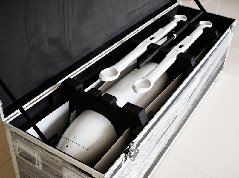
About logistics or freight transportation
■ About 15 days after the order is issued and can be delivered, sealed container transportation.
■ Shenyang Linghang Aviation Science&Technonlogy Co., Ltd. The self-designed container is strong, safe, simple and beautiful, and can effectively protect the UAV in the container.